|
No
|
Title
|
Year
|
Place
|
|
1
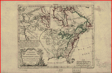
|
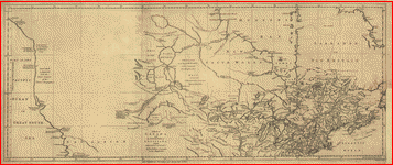
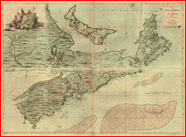
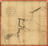
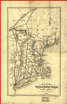
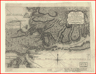
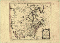
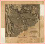
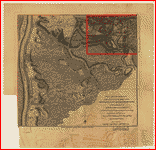
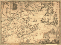 This map of the province of
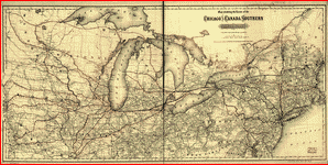
Nova-Scotia and parts adjacent. .
Turner, James, d. 1759. CREATED/PUBLISHED Philadelphia; Printed and sold by
R. Aitken [1776] NOTES Scale ca. 1:3,750,000. Relief shown pictorially. Shows
the Maritime Provinces, Newfoundland, and the St. Laurence River Valley
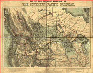
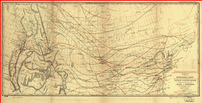
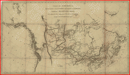
between 1755 and 1757. Inscribed to "His Majesty's Province of Nova
Scotia ... " Includes "View of
Boston," inset of Halifax Harbor, and insets, with indexes, of Halifax,
Quebec, and "City & port of Louisbourg." This map of the province of
Nova-Scotia and parts adjacent. .
Turner, James, d. 1759. CREATED/PUBLISHED Philadelphia; Printed and sold by
R. Aitken [1776] NOTES Scale ca. 1:3,750,000. Relief shown pictorially. Shows
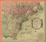
the Maritime Provinces, Newfoundland, and the St. Laurence River Valley
between 1755 and 1757. Inscribed to "His Majesty's Province of Nova
Scotia ... " Includes "View of
Boston," inset of Halifax Harbor, and insets, with indexes, of Halifax,
Quebec, and "City & port of Louisbourg."
|
1759
|
Maritimes
|
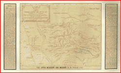
|
2
|
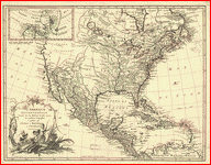
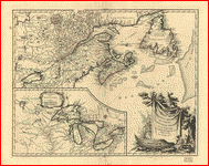 Partie de l'Amérique
septent? qui comprend la Nouvelle France ou le Canada. par le
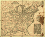
Sr. Robert de Vaugondy, géog? ordinaire du roy. Avec privilege 1755. C. Haussard,
sculp. Robert de Vaugondy, Gilles, 1688-1766.
CREATED/PUBLISHED [Paris, 1758] NOTES Scale ca. 1:4,000,000. Relief shown
pictorially. Partie de l'Amérique
septent? qui comprend la Nouvelle France ou le Canada. par le
Sr. Robert de Vaugondy, géog? ordinaire du roy. Avec privilege 1755. C. Haussard,
sculp. Robert de Vaugondy, Gilles, 1688-1766.
CREATED/PUBLISHED [Paris, 1758] NOTES Scale ca. 1:4,000,000. Relief shown
pictorially.
|
1755
|
New France
|
|
3
|
 Canada et
Louisiane, par le Sr. le Rouge ingénieur géographe du Roy. . Le Rouge, Georges-Louis.
CREATED/PUBLISHED Paris, 1755. NOTES Scale ca. 1:4,450,000. Relief shown pictorially.
Includes illus. of Niagara Falls and additional place-names. Canada et
Louisiane, par le Sr. le Rouge ingénieur géographe du Roy. . Le Rouge, Georges-Louis.
CREATED/PUBLISHED Paris, 1755. NOTES Scale ca. 1:4,450,000. Relief shown pictorially.
Includes illus. of Niagara Falls and additional place-names.
|
1755
|
New France
|
|
4
|
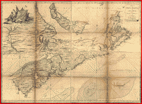
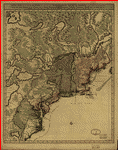
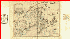 A new map of Nova Scotia, and Cape
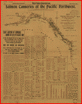
Breton Island with the adjacent parts of New England and Canada, composed
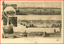
from a great number of actual surveys; and other materials regulated by many
new astronomical observations of the longitude as well as latitude. Jefferys,
Thomas, d. 1771. CREATED/PUBLISHED London; Printed & sold by R. Sayer & J. Bennett, 1775. NOTES Scale ca.
1:1,900,000. Relief shown pictorially. Depths shown by soundings.
"VII" located above upper right corner of border. Shows Maritime
Provinces, New England, and St. Lawrence Valley region to Montreal. Includes
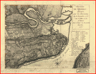
table of sources of observations. A new map of Nova Scotia, and Cape
Breton Island with the adjacent parts of New England and Canada, composed
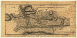
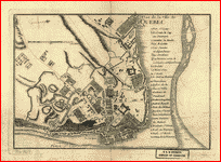
from a great number of actual surveys; and other materials regulated by many
new astronomical observations of the longitude as well as latitude. Jefferys,
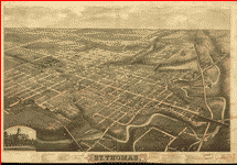
Thomas, d. 1771. CREATED/PUBLISHED London; Printed & sold by R. Sayer & J. Bennett, 1775. NOTES Scale ca.
1:1,900,000. Relief shown pictorially. Depths shown by soundings.
"VII" located above upper right corner of border. Shows Maritime
Provinces, New England, and St. Lawrence Valley region to Montreal. Includes
table of sources of observations.
|
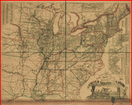
1775
|
Maritimes
|
|
5
|
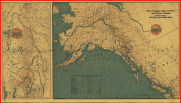
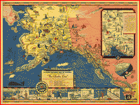 The Alaska Line. . CREATED/PUBLISHED [S.l.], 1934. The Alaska Line. . CREATED/PUBLISHED [S.l.], 1934.
|
1934
|
Alaska
|
|
6
|
 Partie
orientale du Canada, traduitte de l'anglois de la carte de Jefferys publiée a
Londres en May 1755. . Le
Rouge, Georges-Louis. CREATED/PUBLISHED Paris [1755?] NOTES Scale ca.
1:2,000,000. Relief shown pictorially. Prime meridian: Isle de Fer. Includes "Table comparative." Partie
orientale du Canada, traduitte de l'anglois de la carte de Jefferys publiée a
Londres en May 1755. . Le
Rouge, Georges-Louis. CREATED/PUBLISHED Paris [1755?] NOTES Scale ca.
1:2,000,000. Relief shown pictorially. Prime meridian: Isle de Fer. Includes "Table comparative."
|
1755
|
Maritimes
|
|
7
|
 La
Nouvelle France où Canada. . Bellin,
Jacques Nicolas, 1703-1772. CREATED/PUBLISHED [Paris, 1764] NOTES Scale ca.
1:9,000,000. Relief shown pictorially. Depths shown by soundings. La
Nouvelle France où Canada. . Bellin,
Jacques Nicolas, 1703-1772. CREATED/PUBLISHED [Paris, 1764] NOTES Scale ca.
1:9,000,000. Relief shown pictorially. Depths shown by soundings.
|
1764
|
New France
|
|
8
|
 A map of Canada and the north part
of Louisiana with the adjacent countrys. . Jefferys,
Thomas, d. 1771. CREATED/PUBLISHED London [1768] NOTES Scale ca. 1:8,000,000.
Relief shown pictorially. A map of Canada and the north part
of Louisiana with the adjacent countrys. . Jefferys,
Thomas, d. 1771. CREATED/PUBLISHED London [1768] NOTES Scale ca. 1:8,000,000.
Relief shown pictorially.
|
1768
|
New France
|
|
9
|
 A map of Canada and the north part
of Louisiana with the adjacent countrys.. Jefferys,
Thomas, d. 1771. CREATED/PUBLISHED London [1768] NOTES Scale ca. 1:8,000,000.
Relief shown pictorially. Shows the Pacific Coast from 400 N. lat. to 600 N.
lat. A map of Canada and the north part
of Louisiana with the adjacent countrys.. Jefferys,
Thomas, d. 1771. CREATED/PUBLISHED London [1768] NOTES Scale ca. 1:8,000,000.
Relief shown pictorially. Shows the Pacific Coast from 400 N. lat. to 600 N.
lat.
|
1768
|
New France
|
|
10
|
 Carte des
possessions françoises et angloises dans le Canada, et partie de la
Louisiane, 1756.. Longchamps,
géographe. CREATED/PUBLISHED Paris [1769] NOTES
Scale ca. 1:3,900,000. Relief shown pictorially. Includes map extension
entitled "Supplement pour les possessions françoises
et angloises au sud de la
Louisiane. Gravé par Chambon." Carte des
possessions françoises et angloises dans le Canada, et partie de la
Louisiane, 1756.. Longchamps,
géographe. CREATED/PUBLISHED Paris [1769] NOTES
Scale ca. 1:3,900,000. Relief shown pictorially. Includes map extension
entitled "Supplement pour les possessions françoises
et angloises au sud de la
Louisiane. Gravé par Chambon."
|
1769
|
New France
|
|
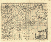
11
|
 Partie
occidentale de la Nouvelle France. ou du Canada par Mr. Bellin,
ingénieur du roy de la marine pour servir à l'intelligence des affaires de
l'etat present en Amerique, communiquée au public par les Héritiers de Homan.
Bellin, Jacques Nicolas, 1703-1772.
CREATED/PUBLISHED [Nürnberg] 1755. NOTES Scale ca.
1:3,500,000. Relief shown pictorially. Covers the area from Lake Superior to
Kaskaskia and from Delaware Bay to the Mississippi River. Shows a few towns,
missions, forts, Indian villages and tribal territory, rivers and lakes,
portages, and early place-names. Partie
occidentale de la Nouvelle France. ou du Canada par Mr. Bellin,
ingénieur du roy de la marine pour servir à l'intelligence des affaires de
l'etat present en Amerique, communiquée au public par les Héritiers de Homan.
Bellin, Jacques Nicolas, 1703-1772.
CREATED/PUBLISHED [Nürnberg] 1755. NOTES Scale ca.
1:3,500,000. Relief shown pictorially. Covers the area from Lake Superior to
Kaskaskia and from Delaware Bay to the Mississippi River. Shows a few towns,
missions, forts, Indian villages and tribal territory, rivers and lakes,
portages, and early place-names.
|
1755
|
New France
|
|
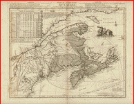
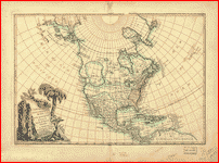
12
|
 Hudson's Bay's country after La Veranderie, about 1740. La Vérendrye, Pierre Gaultier de Varennes, sieur de, 1685-1749. CREATED/PUBLISHED [ca. 1740] NOTES
Relief shown pictorially. Shows lakes, rivers, fortifications, and nations in
western region of Hudson Bay, Canada, and northern United States. A sketch of
the territory explored by De la Veranderie.
"The original of the map in the Dépôt de la
Marine of Paris has the following title: Carte des nouvelles
découvertes dans l'Ouest du Canada et des nations, qui y habitent." Hudson's Bay's country after La Veranderie, about 1740. La Vérendrye, Pierre Gaultier de Varennes, sieur de, 1685-1749. CREATED/PUBLISHED [ca. 1740] NOTES
Relief shown pictorially. Shows lakes, rivers, fortifications, and nations in
western region of Hudson Bay, Canada, and northern United States. A sketch of
the territory explored by De la Veranderie.
"The original of the map in the Dépôt de la
Marine of Paris has the following title: Carte des nouvelles
découvertes dans l'Ouest du Canada et des nations, qui y habitent."
|
1740
|
Hudson’s Bay, west
|
|
13
|
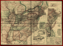
 Map showing the route of the
Chicago and Canada Southern Railway and its connecting lines. . G.W. & C.B. Colton & Co.
CREATED/PUBLISHED New York, 1872. NOTES Scale 1:2,217,600. Map showing the route of the
Chicago and Canada Southern Railway and its connecting lines. . G.W. & C.B. Colton & Co.
CREATED/PUBLISHED New York, 1872. NOTES Scale 1:2,217,600.
|
1872
|
United States, North Central
|
|
14
|
 New railway map and guide of New
York, Pennsylvania and New Jersey with parts of adjoining states and Canada,
1881. . Barrington, W. CREATED/PUBLISHED
Philadelphia, 1881. NOTES Scale ca. 1:675,000. New railway map and guide of New
York, Pennsylvania and New Jersey with parts of adjoining states and Canada,
1881. . Barrington, W. CREATED/PUBLISHED
Philadelphia, 1881. NOTES Scale ca. 1:675,000.
|
1881
|
United States, North East
|
|
15
|
 Partie orientale
du Canada. Traduitte de l'anglois
de la carte de Jefferys publiée
à Londres en May 1755. . Le Rouge, Georges-Louis. CREATED/PUBLISHED Paris, Le
Rouge [1762] NOTES Scale ca. 1:2,000,000. Relief shown pictorially. Text in
French and German. Includes a table of comparative latitudes and longitudes. Partie orientale
du Canada. Traduitte de l'anglois
de la carte de Jefferys publiée
à Londres en May 1755. . Le Rouge, Georges-Louis. CREATED/PUBLISHED Paris, Le
Rouge [1762] NOTES Scale ca. 1:2,000,000. Relief shown pictorially. Text in
French and German. Includes a table of comparative latitudes and longitudes.
|
1762
|
Maritimes
|
|
16
|
 G. Woolworth Colton's railroad,
township & distance map of New England with adjacent portions of New
York, Canada & New Brunswick. . Colton, G. Woolworth (George Woolworth), 1827-1901.
CREATED/PUBLISHED New York, 1861. NOTES Scale 1:900,000. LC also has 1875 and
1884 editions. Description derived from published bibliography. Inset: The
eastern portion of Massachusetts on an enlarged scale. 28 x 23 cm. G. Woolworth Colton's railroad,
township & distance map of New England with adjacent portions of New
York, Canada & New Brunswick. . Colton, G. Woolworth (George Woolworth), 1827-1901.
CREATED/PUBLISHED New York, 1861. NOTES Scale 1:900,000. LC also has 1875 and
1884 editions. Description derived from published bibliography. Inset: The
eastern portion of Massachusetts on an enlarged scale. 28 x 23 cm.
|
1861
|
New England
|
|
17
|
 Map of the country tributary to
the Northern Pacific Railroad, compiled from English, Canadian, and American
official sources and original surveys by Edward H. Knight, Jan. 1st 1871. . Knight, E. H. (Edward H.)
CREATED/PUBLISHED [n.p., 1871] NOTES Scale ca.
1:3,000,000. SUMMARY Map of northwest part of United States and southwest
part of Canada showing relief by hachures, drainage, isotherms, the wheat
region, cities and towns, forts, routes and trails, the railroad network and
the proposed Northern Pacific Railroad. The line was constructed under an act
of Congress approved by Abraham Lincoln, July 2, 1864. It was completed in
1883 and approximates the route of exploration taken by Lewis and Clark in
1804-06. Map of the country tributary to
the Northern Pacific Railroad, compiled from English, Canadian, and American
official sources and original surveys by Edward H. Knight, Jan. 1st 1871. . Knight, E. H. (Edward H.)
CREATED/PUBLISHED [n.p., 1871] NOTES Scale ca.
1:3,000,000. SUMMARY Map of northwest part of United States and southwest
part of Canada showing relief by hachures, drainage, isotherms, the wheat
region, cities and towns, forts, routes and trails, the railroad network and
the proposed Northern Pacific Railroad. The line was constructed under an act
of Congress approved by Abraham Lincoln, July 2, 1864. It was completed in
1883 and approximates the route of exploration taken by Lewis and Clark in
1804-06.
|
1871
|
Canada, west - United States
|
|
18
|
 A correct map of the seat of war. . Lewis, Samuel. CREATED/PUBLISHED
[S.l., 1812] A correct map of the seat of war. . Lewis, Samuel. CREATED/PUBLISHED
[S.l., 1812]
|
1812
|
Canada, Upper - New England
|
|
19
|
 Louisiana. . Lewis, Samuel, 1753 or 4-1822.
CREATED/PUBLISHED [S.l., 1805] Louisiana. . Lewis, Samuel, 1753 or 4-1822.
CREATED/PUBLISHED [S.l., 1805]
|
1805
|
New France
|
|
20
|
 Isothermal chart of the region
north of the 36th Parallel &c. &c. between the Atlantic & Pacific
oceans; compiled under the direction of Isaac I. Stevens, Govnr.
of Washington Territory. . Stevens, Isaac Ingalls,
1818-1862. CREATED/PUBLISHED New York, [1859] NOTES Scale 1:7,450,000. From
36th Congress, 1st session House. Ex. doc. no. 56. SUMMARY Indicates
"practicable railroad lines," and "proposed railroad
lines." Summer isotherms are in red, winter isotherms are in blue. Isothermal chart of the region
north of the 36th Parallel &c. &c. between the Atlantic & Pacific
oceans; compiled under the direction of Isaac I. Stevens, Govnr.
of Washington Territory. . Stevens, Isaac Ingalls,
1818-1862. CREATED/PUBLISHED New York, [1859] NOTES Scale 1:7,450,000. From
36th Congress, 1st session House. Ex. doc. no. 56. SUMMARY Indicates
"practicable railroad lines," and "proposed railroad
lines." Summer isotherms are in red, winter isotherms are in blue.
|
1859
|
North America, Central
|
|
21
|
 Map of Nova Scotia, or Acadia;
with the islands of Cape Breton and St. John's, from actual surveys, by Captn. Montresor, engir. .
Montrésor, John, 1736-1799. CREATED/PUBLISHED
London; Printed & sold by A. Dury, 1768. NOTES
Scale ca. 1:390,000. Relief shown pictorially and by hachures. Depths shown
by soundings. Shows administrative boundaries on St. John's Island. Includes
inscription to "John Manners." Map of Nova Scotia, or Acadia;
with the islands of Cape Breton and St. John's, from actual surveys, by Captn. Montresor, engir. .
Montrésor, John, 1736-1799. CREATED/PUBLISHED
London; Printed & sold by A. Dury, 1768. NOTES
Scale ca. 1:390,000. Relief shown pictorially and by hachures. Depths shown
by soundings. Shows administrative boundaries on St. John's Island. Includes
inscription to "John Manners."
|
1768
|
Nova Scotia
|
|
22
|
 Map of Nova Scotia, or Acadia;
with the islands of Cape Breton and St. John's, from actual surveys, by Captn. Montresor, engir., 1768. . Montrésor, John, 1736-1799.
CREATED/PUBLISHED London; Printed & sold by A. Dury
[1768] NOTES Scale ca. 1:390,000; 60 miles to a degree. Relief shown
pictorially. Depths shown by soundings. Map of Nova Scotia, or Acadia;
with the islands of Cape Breton and St. John's, from actual surveys, by Captn. Montresor, engir., 1768. . Montrésor, John, 1736-1799.
CREATED/PUBLISHED London; Printed & sold by A. Dury
[1768] NOTES Scale ca. 1:390,000; 60 miles to a degree. Relief shown
pictorially. Depths shown by soundings.
|
1768
|
Nova Scotia
|
|
23
|
 Lloyd's railroad, telegraph &
express map of the United States and Canadas from
official information. .
Lloyd, James T. CREATED/PUBLISHED New York, 1867. NOTES Scale ca.
1:2,300,000. Annotated in red and blue to show major railroad and steamboat
lines in the North East. Lloyd's railroad, telegraph &
express map of the United States and Canadas from
official information. .
Lloyd, James T. CREATED/PUBLISHED New York, 1867. NOTES Scale ca.
1:2,300,000. Annotated in red and blue to show major railroad and steamboat
lines in the North East.
|
1867
|
Canada - United States, east
|
|
24
|
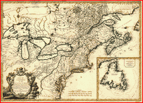 Carte du
Canada et des Etats-Unis de l'Amérique Septentrionale. par le
Sr. Robert de Vaugondy, Géog. Ord. du Roi ... et Censeur Royal. Robert de
Vaugondy, Gilles, 1688-1766. CREATED/PUBLISHED Paris : Chez Fortin, Ing'r
mécanicien du Roi pour les globes et sphères, 1778. NOTES Covers Canada east of Lake Superior and south of
James Bay; covers U.S. north of Albemarle Bay (N.C.). Relief shown
pictorially. Meridians numbered eastward from unspecified prime (Montréal at
3050E). Believed to be the earlist map to use the
name United States of America (in any language). Includes Newfoundland inset
and pictorial title cartouche. Carte du
Canada et des Etats-Unis de l'Amérique Septentrionale. par le
Sr. Robert de Vaugondy, Géog. Ord. du Roi ... et Censeur Royal. Robert de
Vaugondy, Gilles, 1688-1766. CREATED/PUBLISHED Paris : Chez Fortin, Ing'r
mécanicien du Roi pour les globes et sphères, 1778. NOTES Covers Canada east of Lake Superior and south of
James Bay; covers U.S. north of Albemarle Bay (N.C.). Relief shown
pictorially. Meridians numbered eastward from unspecified prime (Montréal at
3050E). Believed to be the earlist map to use the
name United States of America (in any language). Includes Newfoundland inset
and pictorial title cartouche.
|
1778
|
Canada - United States, east
|
|
25
|
 A map of Mackenzie's track from
Fort Chipewyan to the Pacific Ocean in 1793. . Mackenzie, Alexander, d. 1820. CREATED/PUBLISHED London : Published by Alexander MacKenzie,
1801. A map of Mackenzie's track from
Fort Chipewyan to the Pacific Ocean in 1793. . Mackenzie, Alexander, d. 1820. CREATED/PUBLISHED London : Published by Alexander MacKenzie,
1801.
|
1801
|
Canada, north
|
|
26
|
 A map of Mackenzie's track from
Fort Chipewyan to the north sea in 1789. . Mackenzie, Alexander, d. 1820. CREATED/PUBLISHED London : Published by Alexander MacKenzie,
1801. A map of Mackenzie's track from
Fort Chipewyan to the north sea in 1789. . Mackenzie, Alexander, d. 1820. CREATED/PUBLISHED London : Published by Alexander MacKenzie,
1801.
|
1801
|
Canada, north
|
|
27
|
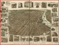 City of Ottawa, Canada with views
of principal business buildings. . Toronto Lithographing Co. CREATED/PUBLISHED [Toronto?
1895?] NOTES Perspective map not drawn to scale. Bird's-eye view. City of Ottawa, Canada with views
of principal business buildings. . Toronto Lithographing Co. CREATED/PUBLISHED [Toronto?
1895?] NOTES Perspective map not drawn to scale. Bird's-eye view.
|
1895
|
Ottawa
|
|
28
|
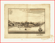 Vue de
Quebec, capitale du Canada. . [Le
Rouge, Georges-Louis] CREATED/PUBLISHED [Paris, 1755] NOTES Includes "Renvois" indicating 10 important buildings as seen
from the east. Vue de
Quebec, capitale du Canada. . [Le
Rouge, Georges-Louis] CREATED/PUBLISHED [Paris, 1755] NOTES Includes "Renvois" indicating 10 important buildings as seen
from the east.
|
|
Quebec City
|
|
29
|
 Carte du
Canada et de la Louisiane qui forment la Nouvelle France et des colonies
angloises ou sont representez les pays contestez. . Nolin, Jean Baptiste, 1686-1762.
CREATED/PUBLISHED Paris, Chez Daumont, 1756. NOTES
Scale ca. 1:5,000,000. Relief shown pictorially and by hachures. Carte du
Canada et de la Louisiane qui forment la Nouvelle France et des colonies
angloises ou sont representez les pays contestez. . Nolin, Jean Baptiste, 1686-1762.
CREATED/PUBLISHED Paris, Chez Daumont, 1756. NOTES
Scale ca. 1:5,000,000. Relief shown pictorially and by hachures.
|
1756
|
New France
|
|
30
|
 Birds eye view of the city of Port
Huron, Sarnia & Gratiot, St. Clair Co., Michigan 1867 & Point
Edwards, Lambton Co., Canada west. . Ruger, A. CREATED/PUBLISHED
Chicago, Chicago Lithographing Co. [1867] NOTES Perspective map not drawn to
scale. Indexed for points of interest. Birds eye view of the city of Port
Huron, Sarnia & Gratiot, St. Clair Co., Michigan 1867 & Point
Edwards, Lambton Co., Canada west. . Ruger, A. CREATED/PUBLISHED
Chicago, Chicago Lithographing Co. [1867] NOTES Perspective map not drawn to
scale. Indexed for points of interest.
|
1867
|
Port Huron
|
|
31
|
 Winnipeg. entered
according to Act of Parliament of Canada in the year 1884 by W.G. Fonseca in
the Office of the Minister of Agriculture. Fonseca, W. G. CREATED/PUBLISHED Ottawa : Mortimer & Co., 1884. NOTES Bird's-eye view.
Includes statistical data and ill. Winnipeg. entered
according to Act of Parliament of Canada in the year 1884 by W.G. Fonseca in
the Office of the Minister of Agriculture. Fonseca, W. G. CREATED/PUBLISHED Ottawa : Mortimer & Co., 1884. NOTES Bird's-eye view.
Includes statistical data and ill.
|
1884
|
Winnipeg
|
|
32
|
 Bird's eye view of Brantford,
province Ontario, Canada 1875. .
Drawn by H. Brosius. Chas. Shober
& Co. prop's Chicago Lith. Co. CREATED/PUBLISHED [n.p.,
1875] NOTES Perspective map not drawn to scale. Includes illus. and index to
points of interest. Bird's eye view of Brantford,
province Ontario, Canada 1875. .
Drawn by H. Brosius. Chas. Shober
& Co. prop's Chicago Lith. Co. CREATED/PUBLISHED [n.p.,
1875] NOTES Perspective map not drawn to scale. Includes illus. and index to
points of interest.
|
1875
|
Brantford
|
|
33
|
 Watson's new rail-road and
distance map of the United States and Canada, 1871. Watson, Gaylord.
CREATED/PUBLISHED New York, 1871, c1868. NOTES Scale ca. 1:2,300,000.
"Special railroad maps to accompany reports &c., prepared at short
notice, and in best style. Address Gaylord Watson, 16 Beckman Street, New
York." Annotated in colored crayons to show "Voyage of duck-boat
Centennial Republic" and "paper canoe Maria Theresa." Watson's new rail-road and
distance map of the United States and Canada, 1871. Watson, Gaylord.
CREATED/PUBLISHED New York, 1871, c1868. NOTES Scale ca. 1:2,300,000.
"Special railroad maps to accompany reports &c., prepared at short
notice, and in best style. Address Gaylord Watson, 16 Beckman Street, New
York." Annotated in colored crayons to show "Voyage of duck-boat
Centennial Republic" and "paper canoe Maria Theresa."
|
1868
|
United States, east
|
|
34
|
 The upper Mississippi and Missouri . Soulard,
Anthoine, 1766-1825. OTHER TITLES IDEE topographique des huts de Mississipi
et du Missouri CREATED/PUBLISHED [185-] NOTES Covers Northwestern States and
Western Canada. Relief shown pictorially. French. Title in English. Traced by
J.G. Kohl from the original map: IDEE topographique
des huts de Mississipi et du Missouri ... / dessinee par Mr. Soulard ancien S. Lant de port de la
marine Rle de France et Capt. des milices de S.M.C. aux yllinois
...... The upper Mississippi and Missouri . Soulard,
Anthoine, 1766-1825. OTHER TITLES IDEE topographique des huts de Mississipi
et du Missouri CREATED/PUBLISHED [185-] NOTES Covers Northwestern States and
Western Canada. Relief shown pictorially. French. Title in English. Traced by
J.G. Kohl from the original map: IDEE topographique
des huts de Mississipi et du Missouri ... / dessinee par Mr. Soulard ancien S. Lant de port de la
marine Rle de France et Capt. des milices de S.M.C. aux yllinois
......
|
1850
|
Canada - United States, Midwest
|
|
35
|
 A map of America between latitudes
40 and 70 north and longitudes 45 and 180 west exhibiting Mackenzie's track
from Montreal to Fort Chipewyan & from thence to the north sea in 1789
& to the west Pacific Ocean in 1793. . Mackenzie, Alexander, d. 1820. CREATED/PUBLISHED London : Published by Alexander Mack Kenzie,
1801. NOTES "... Published 15 Oct. 1801 ..." Relief shown by
hachures. A map of America between latitudes
40 and 70 north and longitudes 45 and 180 west exhibiting Mackenzie's track
from Montreal to Fort Chipewyan & from thence to the north sea in 1789
& to the west Pacific Ocean in 1793. . Mackenzie, Alexander, d. 1820. CREATED/PUBLISHED London : Published by Alexander Mack Kenzie,
1801. NOTES "... Published 15 Oct. 1801 ..." Relief shown by
hachures.
|
1801
|
Canada
|
|
36
|
 Bowles's new pocket map of the
United States of America; the British possessions of Canada, Nova Scotia, and
Newfoundland, with the French and Spanish territories of Louisiana and
Florida, as settled by the preliminary articles of peace signed at Versailles
the 20th. Jany. 1783. . Bowles, Carington, 1724-1793.
CREATED/PUBLISHED London, 1784. NOTES Scale ca. 1:6,500,000. Relief shown
pictorially. Prime meridian: Ferro and London. Includes historic notes,
listing of "The 13 United States of America," and inset
"Article III." Bowles's new pocket map of the
United States of America; the British possessions of Canada, Nova Scotia, and
Newfoundland, with the French and Spanish territories of Louisiana and
Florida, as settled by the preliminary articles of peace signed at Versailles
the 20th. Jany. 1783. . Bowles, Carington, 1724-1793.
CREATED/PUBLISHED London, 1784. NOTES Scale ca. 1:6,500,000. Relief shown
pictorially. Prime meridian: Ferro and London. Includes historic notes,
listing of "The 13 United States of America," and inset
"Article III."
|
1784
|
New France
|
|
37
|
 Map of the Stanstead,
Shefford, and Chambly Rail Road, and its
connections. .
Robertson & Seibert. CREATED/PUBLISHED N[ew] Y[ork], 1858. NOTES Scale ca. 1:2,250,000. Description
derived from published bibliography. SUMMARY Map of the New England states
and part of Canada showing the railroad network, relief by hachures, and
place names. Map of the Stanstead,
Shefford, and Chambly Rail Road, and its
connections. .
Robertson & Seibert. CREATED/PUBLISHED N[ew] Y[ork], 1858. NOTES Scale ca. 1:2,250,000. Description
derived from published bibliography. SUMMARY Map of the New England states
and part of Canada showing the railroad network, relief by hachures, and
place names.
|
1858
|
New England
|
|
38
|
 Map of Alaska, Yukon Territory and
British Columbia showing connections of the White Pass and Yukon route. . Marsh & Grant Co.
CREATED/PUBLISHED [S.l.], 1904. NOTES Includes
inset. Table of distances from Skaguay. Map of Alaska, Yukon Territory and
British Columbia showing connections of the White Pass and Yukon route. . Marsh & Grant Co.
CREATED/PUBLISHED [S.l.], 1904. NOTES Includes
inset. Table of distances from Skaguay.
|
1904
|
Pacific Northwest
|
|
39
|
 Railroad map of the eastern,
western and northern states, and Canada, showing conspicuously the lines of
communication between the ports of the Atlantic and the great west and north
west. . Mitchell's Map Publication
Office. CREATED/PUBLISHED Philadelphia, 1859. NOTES Scale ca. 1:2,200,000.
SUMMARY General map covering the northeastern and north-central United States
and part of eastern Canada. Shows drainage, cities, roads, canals, and
"railroads completed" and "in progress." Railroad map of the eastern,
western and northern states, and Canada, showing conspicuously the lines of
communication between the ports of the Atlantic and the great west and north
west. . Mitchell's Map Publication
Office. CREATED/PUBLISHED Philadelphia, 1859. NOTES Scale ca. 1:2,200,000.
SUMMARY General map covering the northeastern and north-central United States
and part of eastern Canada. Shows drainage, cities, roads, canals, and
"railroads completed" and "in progress."
|
1859
|
Canada - United States, Northeast
|
|
40
|
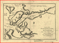 Carte des
bayes, rades et port de Plaisance dans l'Isle de Terre-Neuve. Dressé par M. Bellin
pour l'Histoire du Canada par le P. Charlevoix. . Bellin,
Jacques Nicolas, 1703-1772. CREATED/PUBLISHED [Paris, 1755] NOTES Scale ca.
1:58,500; 2,000 toises = 77 mm. Relief shown by
hachures. Depths shown by soundings. Carte des
bayes, rades et port de Plaisance dans l'Isle de Terre-Neuve. Dressé par M. Bellin
pour l'Histoire du Canada par le P. Charlevoix. . Bellin,
Jacques Nicolas, 1703-1772. CREATED/PUBLISHED [Paris, 1755] NOTES Scale ca.
1:58,500; 2,000 toises = 77 mm. Relief shown by
hachures. Depths shown by soundings.
|
1755
|
New France
|
|
41
|
 A Plan of the Straits of St. Mary,
and Michilimakinac, to shew
the situation & importance of the two westernmost settlements of Canada
for the fur trade. .
CREATED/PUBLISHED [n.p., 175-?] NOTES Scale ca.
1:75,000. A Plan of the Straits of St. Mary,
and Michilimakinac, to shew
the situation & importance of the two westernmost settlements of Canada
for the fur trade. .
CREATED/PUBLISHED [n.p., 175-?] NOTES Scale ca.
1:75,000.
|
1750
|
Great Lakes
|
|
42
|
 New York, New Jersey,
Pennsylvania, Delaware, Maryland, Ohio and Canada, with parts of adjoining
states. . Colton, G. Woolworth (George
Woolworth), 1827-1901. CREATED/PUBLISHED New York, 1860. NOTES Scale
1:1,267,200. At head of title: "G. Woolworth Colton's series of railroad
maps, No 3." "Printed for the History of the Railroads of the
United States by H. V. Poor." New York, New Jersey,
Pennsylvania, Delaware, Maryland, Ohio and Canada, with parts of adjoining
states. . Colton, G. Woolworth (George
Woolworth), 1827-1901. CREATED/PUBLISHED New York, 1860. NOTES Scale
1:1,267,200. At head of title: "G. Woolworth Colton's series of railroad
maps, No 3." "Printed for the History of the Railroads of the
United States by H. V. Poor."
|
1860
|
New England
|
|
43
|
 Map shewing
the several routes proposed for the passage of gunboats to the Lakes via:
Erie and Oswego Canal; Champlain [Canal]; Illinois River and Chicago [Canal];
Wisconsin, Green Bay [Canal] Prepared by S. H. Sweet, Dep. State Engr. and
Surveyor. .
CREATED/PUBLISHED Albany, N.Y., Lith. of C. Van Benthuysen,
1862. NOTES Scale ca. 1:3,600,000. Shows canals and navigation routes in
northeastern United States and southeastern Canada. Includes distance chart. Map shewing
the several routes proposed for the passage of gunboats to the Lakes via:
Erie and Oswego Canal; Champlain [Canal]; Illinois River and Chicago [Canal];
Wisconsin, Green Bay [Canal] Prepared by S. H. Sweet, Dep. State Engr. and
Surveyor. .
CREATED/PUBLISHED Albany, N.Y., Lith. of C. Van Benthuysen,
1862. NOTES Scale ca. 1:3,600,000. Shows canals and navigation routes in
northeastern United States and southeastern Canada. Includes distance chart.
|
1862
|
Canada - United States, East
|
|
44
|
 Carte de
l'Amerique Septentrionnale : depuis le 25, jusqu'au 650 deg. de latt. & environ 140, & 235 deg.
de longitude / par Iean Baptiste
Louis Franquelin, hydrographe
du roy, à Québec en Canada. . Franquelin,
Jean Baptiste Louis. CREATED/PUBLISHED [1688] NOTES
In margin; Bibliotheque du Depot des cartes et plans de la Marina, Paris, Atlas 4040B, piece
n. 3. Indexed inset of view: Quebec comme il se voit du cóté de l'Est. Carte de
l'Amerique Septentrionnale : depuis le 25, jusqu'au 650 deg. de latt. & environ 140, & 235 deg.
de longitude / par Iean Baptiste
Louis Franquelin, hydrographe
du roy, à Québec en Canada. . Franquelin,
Jean Baptiste Louis. CREATED/PUBLISHED [1688] NOTES
In margin; Bibliotheque du Depot des cartes et plans de la Marina, Paris, Atlas 4040B, piece
n. 3. Indexed inset of view: Quebec comme il se voit du cóté de l'Est.
|
1688
|
New France
|
|
45
|
 Dinsmore's complete map of the railroads
& canals in the United States & Canada carefully compiled from
authentic sources . by
Richard S. Fisher, editor of the American Rail Road & Steam Navigation
Guide. CREATED/PUBLISHED New York, 1856. NOTES Scale ca. 1:4,000,000. Dinsmore's complete map of the railroads
& canals in the United States & Canada carefully compiled from
authentic sources . by
Richard S. Fisher, editor of the American Rail Road & Steam Navigation
Guide. CREATED/PUBLISHED New York, 1856. NOTES Scale ca. 1:4,000,000.
|
1856
|
United States - Canada, east
|
|
46
|
 Maine, New Hampshire, Vermont,
Massachusetts, Rhode Island, Connecticut and Lower Canada, 1860. . Colton, G. Woolworth (George
Woolworth), 1827-1901. CREATED/PUBLISHED New York, 1860. NOTES Scale ca.
1:900,000. Maine, New Hampshire, Vermont,
Massachusetts, Rhode Island, Connecticut and Lower Canada, 1860. . Colton, G. Woolworth (George
Woolworth), 1827-1901. CREATED/PUBLISHED New York, 1860. NOTES Scale ca.
1:900,000.
|
1860
|
New England
|
|
47
|
 Plan of a rout undertaken in
winter, Jany. 26th, from Quebec, the capital of
Canada, to the frontier settlements of the Township of Topsham near Brunswick
Fort on the River Ammerascaegun in the Province of
New Hampshire, Feby. 20th 1760 . Montrésor, John, 1736-1799.
CREATED/PUBLISHED [1760?] NOTES Scale 1:506,880; miles 8 to an in. Oriented
with north to the right. Relief shown pictorially. Plan of a rout undertaken in
winter, Jany. 26th, from Quebec, the capital of
Canada, to the frontier settlements of the Township of Topsham near Brunswick
Fort on the River Ammerascaegun in the Province of
New Hampshire, Feby. 20th 1760 . Montrésor, John, 1736-1799.
CREATED/PUBLISHED [1760?] NOTES Scale 1:506,880; miles 8 to an in. Oriented
with north to the right. Relief shown pictorially.
|
1760
|
St. Lawrence
|
|
48
|
 Ensign, Bridgman & Fanning's
rail road map of the Eastern States. . Ensign, Bridgman & Fanning. CREATED/PUBLISHED New
York, 1856. NOTES Scale [ca. 1:3,000,000]. Description derived from published
bibliography. Insets: Plan of the New England States, on an enlarged scale.
Niagara Falls, Canada side. SUMMARY Map of New England, part of eastern
Canada, New York, Pennsylvania, New Jersey, Delaware, most of Maryland, and
part of Virginia. Shows drainage, some relief by hachures, place names, and
state boundaries. "Names of rail roads which are designated by numbers
on the annexed 'Plan of the New England States'" appear at the right of
the map. Ensign, Bridgman & Fanning's
rail road map of the Eastern States. . Ensign, Bridgman & Fanning. CREATED/PUBLISHED New
York, 1856. NOTES Scale [ca. 1:3,000,000]. Description derived from published
bibliography. Insets: Plan of the New England States, on an enlarged scale.
Niagara Falls, Canada side. SUMMARY Map of New England, part of eastern
Canada, New York, Pennsylvania, New Jersey, Delaware, most of Maryland, and
part of Virginia. Shows drainage, some relief by hachures, place names, and
state boundaries. "Names of rail roads which are designated by numbers
on the annexed 'Plan of the New England States'" appear at the right of
the map.
|
1856
|
New England
|
|
49
|
 Telegraph stations in the United
States, the Canadas & Nova Scotia. . Barr, Chas. B. CREATED/PUBLISHED
[S.l.], 1853. Telegraph stations in the United
States, the Canadas & Nova Scotia. . Barr, Chas. B. CREATED/PUBLISHED
[S.l.], 1853.
|
1853
|
United States - Canada, East
|
|
50
|
 A map of the sources of the
Chaudière, Penobscot, and Kennebec rivers, by Montresore.
. Montrésor,
John, 1736-1799. CREATED/PUBLISHED [1761?] NOTES Scale ca. 1:390,000. Relief
shown pictorially. Shows campsite locations for the author's expedition from
Quebec into Maine. A map of the sources of the
Chaudière, Penobscot, and Kennebec rivers, by Montresore.
. Montrésor,
John, 1736-1799. CREATED/PUBLISHED [1761?] NOTES Scale ca. 1:390,000. Relief
shown pictorially. Shows campsite locations for the author's expedition from
Quebec into Maine.
|
1761
|
Halifax
|
|
51
|
 A map of the north west parts of
America, with the utmost respect, inscrib'd to His
Excellency, Sir Guy Carleton, Knight of the Bath. Captain General and Governor of the province of Quebec:
General and Commander in Chief of His Majesty's forces in the said province,
and frontiers thereof. &c. &c. &c., by his most obedient humble servt. Alexr. Henry. Henry,
Alexander, 1739-1824. CREATED/PUBLISHED [1776?] NOTES Scale ca. 1:2,000,000.
Annotated with names and descriptive notes and letterpress. Shows Indian tribes
of western Ontario, Manitoba, and Saskatchewan. A map of the north west parts of
America, with the utmost respect, inscrib'd to His
Excellency, Sir Guy Carleton, Knight of the Bath. Captain General and Governor of the province of Quebec:
General and Commander in Chief of His Majesty's forces in the said province,
and frontiers thereof. &c. &c. &c., by his most obedient humble servt. Alexr. Henry. Henry,
Alexander, 1739-1824. CREATED/PUBLISHED [1776?] NOTES Scale ca. 1:2,000,000.
Annotated with names and descriptive notes and letterpress. Shows Indian tribes
of western Ontario, Manitoba, and Saskatchewan.
|
1776
|
Canada
|
|
52
|
 Bird's eye view of Sherbrooke, P.Q. . CREATED/PUBLISHED [Sherbrooke,
Québec? : s.n.], 1881.
NOTES Includes index and inset of "Spring Brewery C.H. Fletcher." Bird's eye view of Sherbrooke, P.Q. . CREATED/PUBLISHED [Sherbrooke,
Québec? : s.n.], 1881.
NOTES Includes index and inset of "Spring Brewery C.H. Fletcher."
|
1881
|
Sherbrooke, P.Q.
|
|
53
|
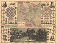 Map of the United States, Canada,
Mexico, West Indies and Central America. . Phelps & Watson. OTHER TITLES Our Country.
CREATED/PUBLISHED New York, Phelps & Watson 1859. NOTES Includes State
seals and portraits of Presidents. Map of the United States, Canada,
Mexico, West Indies and Central America. . Phelps & Watson. OTHER TITLES Our Country.
CREATED/PUBLISHED New York, Phelps & Watson 1859. NOTES Includes State
seals and portraits of Presidents.
|
1859
|
North America
|
|
54
|
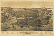 Victoria, B.C. 1889. . Ellis & Co.
CREATED/PUBLISHED Victoria, 1889. NOTES Perspective map not drawn to scale.
Bird's-eye-view. Indexed for points of interest. Victoria, B.C. 1889. . Ellis & Co.
CREATED/PUBLISHED Victoria, 1889. NOTES Perspective map not drawn to scale.
Bird's-eye-view. Indexed for points of interest.
|
1889
|
Victoria, B.C.
|
|
55
|
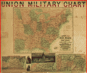 Complete map of the rail roads and
water courses, in the United States & Canada. . Magnus, Charles.
CREATED/PUBLISHED New York, [1861] NOTES Scale ca. 1:5,800,000. In lower
margin of main map is printed "Entered, according to act of Congress, in
the year 1859...." At the bottom edge below the inset neat lines is
printed "Entered, according to act of Congress, in the year
1861...." Insets: Military map of Maryland & Virginia. --Map of
northern military movements: between New York & St. Louis. --[View of the U.S. Capitol] ---[Entrance to Mobile Bay]
--[United States and the Gulf of Mexico]. Complete map of the rail roads and
water courses, in the United States & Canada. . Magnus, Charles.
CREATED/PUBLISHED New York, [1861] NOTES Scale ca. 1:5,800,000. In lower
margin of main map is printed "Entered, according to act of Congress, in
the year 1859...." At the bottom edge below the inset neat lines is
printed "Entered, according to act of Congress, in the year
1861...." Insets: Military map of Maryland & Virginia. --Map of
northern military movements: between New York & St. Louis. --[View of the U.S. Capitol] ---[Entrance to Mobile Bay]
--[United States and the Gulf of Mexico].
|
1861
|
Canada - United States, East
|
|
56
|
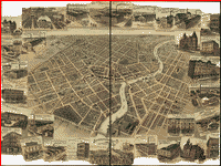 Bird's eye view of Chatham,
Ontario. .
CREATED/PUBLISHED n.p., between 1870 and 1880]
NOTES Perspective map not drawn to scale. Includes illus. Bird's eye view of Chatham,
Ontario. .
CREATED/PUBLISHED n.p., between 1870 and 1880]
NOTES Perspective map not drawn to scale. Includes illus.
|
1870
|
Chatham, Ont.
|
|
57
|
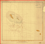 Chart showing the locality where
seals were taken adjacent to the Commander Islands in 1892 by eight Canadian
sealing vessels. .
CREATED/PUBLISHED [S.l.], 1892. Chart showing the locality where
seals were taken adjacent to the Commander Islands in 1892 by eight Canadian
sealing vessels. .
CREATED/PUBLISHED [S.l.], 1892.
|
1892
|
Commander Is.
|
|
58
|
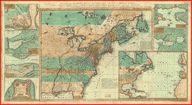
 Nova tabula geographica
complectens borealiorem Americæ partem, in qua exacte delineatæ sunt Canada sive Nova Francia, Nova Scotia, Nova Anglia, Novum
Belgium, Pensylvania, Virginia, Carolina, et Terra
Nova. . Visscher,
Nicolaes. CREATED/PUBLISHED [S.l.,
1717?] Nova tabula geographica
complectens borealiorem Americæ partem, in qua exacte delineatæ sunt Canada sive Nova Francia, Nova Scotia, Nova Anglia, Novum
Belgium, Pensylvania, Virginia, Carolina, et Terra
Nova. . Visscher,
Nicolaes. CREATED/PUBLISHED [S.l.,
1717?]
|
1717
|
New France
|
|
59
|
 A new and accurate map of the
English empire in North America; Representing their rightful claim as
confirmed by charters and the formal surrender of their Indian friends;
likewise the encroachments of the French, with the several forts they have
unjustly erected therein. .
Society of Anti-Gallicans. CREATED/PUBLISHED
London, Sold by Wm. Herbert ... , 1755. NOTES Scale
ca. 1:7,200,000. Relief shown pictorially. "Longitude west from
Ferro." Includes notes. Maps in margin: A plan of the harbor and town of
Louisbourg on the isle of Cape Briton.--A plan of Chebucto Harbor.--The Atlantic Ocean.--Fort Frederick
built by the French at Crown or Scalp Point in the year 1731.--A plan of Port
Dauphin on the isle of Cape Briton.--A plan of the harbour
of Annopolis Royal.--A plan of the town of Quebeck. A new and accurate map of the
English empire in North America; Representing their rightful claim as
confirmed by charters and the formal surrender of their Indian friends;
likewise the encroachments of the French, with the several forts they have
unjustly erected therein. .
Society of Anti-Gallicans. CREATED/PUBLISHED
London, Sold by Wm. Herbert ... , 1755. NOTES Scale
ca. 1:7,200,000. Relief shown pictorially. "Longitude west from
Ferro." Includes notes. Maps in margin: A plan of the harbor and town of
Louisbourg on the isle of Cape Briton.--A plan of Chebucto Harbor.--The Atlantic Ocean.--Fort Frederick
built by the French at Crown or Scalp Point in the year 1731.--A plan of Port
Dauphin on the isle of Cape Briton.--A plan of the harbour
of Annopolis Royal.--A plan of the town of Quebeck.
|
1755
|
New France
|
|
60
|
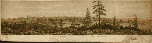 View of Victoria, Vancouver
Island. Drawn by H. O. Tiedemann. T. Picken, lith. . CREATED/PUBLISHED London, Day
& Son, 1860. NOTES Shows points of interest. View of Victoria, Vancouver
Island. Drawn by H. O. Tiedemann. T. Picken, lith. . CREATED/PUBLISHED London, Day
& Son, 1860. NOTES Shows points of interest.
|
1860
|
Victoria, B.C.
|
|
61
|
 Nouveau
Mexique, Louisiane, Canada, et Nlle. Angleterre. Par M. Brion.
. Brion
de la Tour, Louis. CREATED/PUBLISHED Paris, Chez Desnos,
1766. NOTES Scale ca. 1:25,000,000. Relief shown pictorially. Nouveau
Mexique, Louisiane, Canada, et Nlle. Angleterre. Par M. Brion.
. Brion
de la Tour, Louis. CREATED/PUBLISHED Paris, Chez Desnos,
1766. NOTES Scale ca. 1:25,000,000. Relief shown pictorially.
|
1766
|
North America
|
|
62
|
 A Map of the Country in which the
Army under Lt. Gen. Burgoyne acted in the Campaign of 1777 . [Maps of the expedition from Canada of Gen. Burgoyne] A Map of the Country in which the
Army under Lt. Gen. Burgoyne acted in the Campaign of 1777 . [Maps of the expedition from Canada of Gen. Burgoyne]
|
1777
|
Saratoga area, N.Y.
|
|
63
|
 [Maps of the expedition from
Canada of Gen. Burgoyne] - Plan of the action at Huberton
under Brig. Gen. Frazer, 7th July 1777 . [Maps of the expedition from Canada of Gen. Burgoyne] [Maps of the expedition from
Canada of Gen. Burgoyne] - Plan of the action at Huberton
under Brig. Gen. Frazer, 7th July 1777 . [Maps of the expedition from Canada of Gen. Burgoyne]
|
1777
|
Saratoga area, N.Y
|
|
64
|
 Position of the detachment under
Lt. Col. Baum at Walmscock near Bennington, 16th
Aug 1777 . [Maps of the expedition from
Canada of Gen. Burgoyne] Position of the detachment under
Lt. Col. Baum at Walmscock near Bennington, 16th
Aug 1777 . [Maps of the expedition from
Canada of Gen. Burgoyne]
|
1777
|
Saratoga area, N.Y |
|
65
|
 Plan of the encampment and
position of the army under Lt. Gen. Burgoyne, at Swords House, 17th Sept 1777 . [Maps of the expedition from
Canada of Gen. Burgoyne] Plan of the encampment and
position of the army under Lt. Gen. Burgoyne, at Swords House, 17th Sept 1777 . [Maps of the expedition from
Canada of Gen. Burgoyne]
|
1777
|
Saratoga area, N.Y
|
|
66
|
 Plan of the encampment and
position of the army under Lt. Gen. Burgoyne, at Swords House, 19th Sept 1777 . [Maps of the expedition from
Canada of Gen. Burgoyne] Plan of the encampment and
position of the army under Lt. Gen. Burgoyne, at Swords House, 19th Sept 1777 . [Maps of the expedition from
Canada of Gen. Burgoyne]
|
1777
|
Saratoga area, N.Y
|
|
67
|
 Plan of the encampment and
position of the army under Lt. Gen. Burgoyne, at Braemus
Heights, 20th Sept, 7th Oct 1777 .
[Maps of the expedition from Canada of Gen. Burgoyne] Plan of the encampment and
position of the army under Lt. Gen. Burgoyne, at Braemus
Heights, 20th Sept, 7th Oct 1777 .
[Maps of the expedition from Canada of Gen. Burgoyne]
|
1777
|
Saratoga area, N.Y
|
|
68
|
 Plan of the encampment and
position of the army under Lt. Gen. Burgoyne, at Braemus
Heights, 8th Oct 1777 . [Maps of the expedition from
Canada of Gen. Burgoyne] Plan of the encampment and
position of the army under Lt. Gen. Burgoyne, at Braemus
Heights, 8th Oct 1777 . [Maps of the expedition from
Canada of Gen. Burgoyne]
|
1777
|
Saratoga area, N.Y
|
|
69
|
 Plan of the encampment and
position of the army under Lt. Gen. Burgoyne, at Saratoga, 10th Sept 1777 . [Maps of the expedition from
Canada of Gen. Burgoyne] Plan of the encampment and
position of the army under Lt. Gen. Burgoyne, at Saratoga, 10th Sept 1777 . [Maps of the expedition from
Canada of Gen. Burgoyne]
|
1777
|
Saratoga area, N.Y
|
|
70
|
 Victoria, B.C. and vicinity 1884.
By L. Samuel. Lithographed by the West Shore. . CREATED/PUBLISHED Victoria, J.B. Ferguson & Co.,
1884. Victoria, B.C. and vicinity 1884.
By L. Samuel. Lithographed by the West Shore. . CREATED/PUBLISHED Victoria, J.B. Ferguson & Co.,
1884.
|
1884
|
Victoria, B.C.
|
|
71
|
 Partie des
États-Unis de l’Amérique septentrionale. . CREATED/PUBLISHED [n.p., 178-?]
NOTES Scale ca. 1:330,000. Relief shown pictorially. “Méridien
de Philadelphie à 750 13’ de longitude ust de Londres.” Partie des
États-Unis de l’Amérique septentrionale. . CREATED/PUBLISHED [n.p., 178-?]
NOTES Scale ca. 1:330,000. Relief shown pictorially. “Méridien
de Philadelphie à 750 13’ de longitude ust de Londres.”
|
1780
|
North America
|
|
72
|
 Salmon Canneries of the Pacific
Northwest. . D. O.
Haynes & Co. CREATED/PUBLISHED [S.l.], 1901. Salmon Canneries of the Pacific
Northwest. . D. O.
Haynes & Co. CREATED/PUBLISHED [S.l.], 1901.
|
1901
|
Pacific Northwest
|
|
73
|
 Panoramic view of the city of
Halifax, Nova Scotia 1879. .
Ruger, A. CREATED/PUBLISHED [n.p.,
1879] NOTES Perspective map not drawn to scale. Bird's-eye view. Indexed for
points of interest. Panoramic view of the city of
Halifax, Nova Scotia 1879. .
Ruger, A. CREATED/PUBLISHED [n.p.,
1879] NOTES Perspective map not drawn to scale. Bird's-eye view. Indexed for
points of interest.
|
1879
|
Halifax, N.S.
|
|
74
|
 Bird's-eye view of Victoria,
Vancouver Island, B.C. 1878. Drawn by E. S. Glover. A.L. Bancroft & Co.,
lithographers. .
CREATED/PUBLISHED Victoria, M.W. Waitt & Co.,
1878. NOTES Perspective map not drawn to scale. Indexed for points of
interest. Bird's-eye view of Victoria,
Vancouver Island, B.C. 1878. Drawn by E. S. Glover. A.L. Bancroft & Co.,
lithographers. .
CREATED/PUBLISHED Victoria, M.W. Waitt & Co.,
1878. NOTES Perspective map not drawn to scale. Indexed for points of
interest.
|
1878
|
Victoria,
B.C.
|
|
75
|
 Dominia Anglorum
in America Septentrionali. Specialibus
mappis Londini primum a Mollio edita, nunc recusa
ab Hommanianis Hered. .
Homann Erben (Firm)
CREATED/PUBLISHED [Norimbergæ, between 1759 and
1784] NOTES Scales vary. Hand colored. Relief shown pictorially. Sheet title
in Latin and German. Individual map titles and text in German. Maps in
English and German. Includes text and glossary. A. Newfovndland,
od. Terra Nova S. Lavrentii
Bay, die Fisch-Bank, Acadia, nebst
einem Theil New Schotland.--B. New Engelland,
New York, New Yersey und Pensilvania.--C.
Virginia und Maryland.--D. Carolina, nebst einem Theil
von Florida. Dominia Anglorum
in America Septentrionali. Specialibus
mappis Londini primum a Mollio edita, nunc recusa
ab Hommanianis Hered. .
Homann Erben (Firm)
CREATED/PUBLISHED [Norimbergæ, between 1759 and
1784] NOTES Scales vary. Hand colored. Relief shown pictorially. Sheet title
in Latin and German. Individual map titles and text in German. Maps in
English and German. Includes text and glossary. A. Newfovndland,
od. Terra Nova S. Lavrentii
Bay, die Fisch-Bank, Acadia, nebst
einem Theil New Schotland.--B. New Engelland,
New York, New Yersey und Pensilvania.--C.
Virginia und Maryland.--D. Carolina, nebst einem Theil
von Florida.
|
1759
|
Maritimes, New England
|
|
76
|
 A map of the United States of
America, as settled by the peace of 1783. . Fielding, I. CREATED/PUBLISHED London, Decr. 1, 1783. NOTES Covers the area east of the
Mississippi River from Canada to Florida. Shows boundaries, major towns and
cities, forts Indian villages and tribal territory, rivers, and relief. A map of the United States of
America, as settled by the peace of 1783. . Fielding, I. CREATED/PUBLISHED London, Decr. 1, 1783. NOTES Covers the area east of the
Mississippi River from Canada to Florida. Shows boundaries, major towns and
cities, forts Indian villages and tribal territory, rivers, and relief.
|
1783
|
United States, East
|
|
77
|
 Canada,
Louisiane, possessions angl? Par le S. Robert de Vaugondy, géog? ord? du roi.
Gravé par E. Dussy.
. Robert de Vaugondy,
Gilles, 1688-1766. CREATED/PUBLISHED Paris, 1762. NOTES Scale ca.
1:19,000,000. Relief shown pictorially. "Arrivet
inv. th. sculp." Inset: northwestern portion
of the continent. Canada,
Louisiane, possessions angl? Par le S. Robert de Vaugondy, géog? ord? du roi.
Gravé par E. Dussy.
. Robert de Vaugondy,
Gilles, 1688-1766. CREATED/PUBLISHED Paris, 1762. NOTES Scale ca.
1:19,000,000. Relief shown pictorially. "Arrivet
inv. th. sculp." Inset: northwestern portion
of the continent.
|
1762
|
Louisiana
|
|
78
|
 America septentrionalis
oder Mitternächtiger Theil von America, bestehend,
in Neu Brittania Canada, Neu Engeland, Neu Schotland, Neu Jorck, Pensÿlvania,
Carolina Florida Georgien, Woriñen
der grosse S. Laurentius und Ohio Fluss samt den grossen Seen zu erschen seÿn.
. Kilian,
Georg Christoph, 1709-1781. CREATED/PUBLISHED Augspurg [1764?] NOTES Scale not given. Relief shown
pictorially. Map in English, cartouche in German. America septentrionalis
oder Mitternächtiger Theil von America, bestehend,
in Neu Brittania Canada, Neu Engeland, Neu Schotland, Neu Jorck, Pensÿlvania,
Carolina Florida Georgien, Woriñen
der grosse S. Laurentius und Ohio Fluss samt den grossen Seen zu erschen seÿn.
. Kilian,
Georg Christoph, 1709-1781. CREATED/PUBLISHED Augspurg [1764?] NOTES Scale not given. Relief shown
pictorially. Map in English, cartouche in German.
|
1764
|
Maritimes, New England
|
|
79
|
 Environs
de Quebec: Bloque par les Americains du 8. decembre 1775 au 13. mai 1776. . Le Rouge, Georges-Louis.
CREATED/PUBLISHED Paris, Chez le Rouge, 1777. NOTES Scale ca. 1:72,000.
Relief shown by hachures. Includes historic notes and index to military
emplacements and points of interest Environs
de Quebec: Bloque par les Americains du 8. decembre 1775 au 13. mai 1776. . Le Rouge, Georges-Louis.
CREATED/PUBLISHED Paris, Chez le Rouge, 1777. NOTES Scale ca. 1:72,000.
Relief shown by hachures. Includes historic notes and index to military
emplacements and points of interest
|
1777
|
Quebec
|
|
80
|
 Map showing the most direct
commercial route from the Atlantic via L. Ontario, to the province of Upper
Canada, the north western states & territories, and to the Mississippi. . Price, John, scripsit.
CREATED/PUBLISHED New York, [between 1836 and 1841] NOTES Scale [ca.
1:3,000,000]. Shows area from Washington, D.C., north
to above Lake Huron and from Cape Cod to the Mississippi River. Map showing the most direct
commercial route from the Atlantic via L. Ontario, to the province of Upper
Canada, the north western states & territories, and to the Mississippi. . Price, John, scripsit.
CREATED/PUBLISHED New York, [between 1836 and 1841] NOTES Scale [ca.
1:3,000,000]. Shows area from Washington, D.C., north
to above Lake Huron and from Cape Cod to the Mississippi River.
|
1836
|
Great Lakes
|
|
81
|
 Plan de la
ville de Quebec. . Le
Rouge, Georges-Louis. CREATED/PUBLISHED [Paris, 1755] NOTES Scale ca.
1:7,000. Oriented with north to the right. Relief shown by hachures. Shows
fortifications. Indexed for points of interest. Plan de la
ville de Quebec. . Le
Rouge, Georges-Louis. CREATED/PUBLISHED [Paris, 1755] NOTES Scale ca.
1:7,000. Oriented with north to the right. Relief shown by hachures. Shows
fortifications. Indexed for points of interest.
|
1755
|
Quebec
|
|
82
|
 Canada
IIe. feuille, XXXV, B 32. . Bonne,
Rigobert, 1727-1794. CREATED/PUBLISHED [Paris, Chez
Lattré, 1776] NOTES Scale ca. 1:10,500,000. Relief
shown pictorially and by hachures. Covers North America from the Gulf of St.
Lawrence to the Gulf of Mexico, west nearly to the Rocky Mountains. Canada
IIe. feuille, XXXV, B 32. . Bonne,
Rigobert, 1727-1794. CREATED/PUBLISHED [Paris, Chez
Lattré, 1776] NOTES Scale ca. 1:10,500,000. Relief
shown pictorially and by hachures. Covers North America from the Gulf of St.
Lawrence to the Gulf of Mexico, west nearly to the Rocky Mountains.
|
1776
|
Canada - United States, East
|
|
83
|
 St. Thomas. Drawn by H. Brosius. C.H. Vogt, lith. Printed by J. Knauber & Co. . Brosius, H. CREATED/PUBLISHED
Madison, Wis., J. J. Stoner [1896?] NOTES Perspective map not drawn to scale.
Oriented with north toward the lower left. Bird's-eye-view. Includes illus.
and index to points of interest. St. Thomas. Drawn by H. Brosius. C.H. Vogt, lith. Printed by J. Knauber & Co. . Brosius, H. CREATED/PUBLISHED
Madison, Wis., J. J. Stoner [1896?] NOTES Perspective map not drawn to scale.
Oriented with north toward the lower left. Bird's-eye-view. Includes illus.
and index to points of interest.
|
1896
|
St. Thomas, Ont.
|
|
84
|
 Sherman & Smith's railroad,
steam boat & stage route map of New England, New-York and Canada. . Smith, J. Calvin (John Calvin)
CREATED/PUBLISHED New York, 1850. NOTES Scale [ca. 1:1,550,000]. Description
derived from published bibliography. Sherman & Smith's railroad,
steam boat & stage route map of New England, New-York and Canada. . Smith, J. Calvin (John Calvin)
CREATED/PUBLISHED New York, 1850. NOTES Scale [ca. 1:1,550,000]. Description
derived from published bibliography.
|
1850
|
Canada - New England
|
|
85
|
 L'Amérique
septentrionale, dressée sur les mémoires le plus récens des meilleurs
géographes & publée par Cóvens & Mortier. . Cóvens et Mortier.
CREATED/PUBLISHED Amsterdam, 1757. NOTES Scale ca. 1:12,500,000. Relief shown
pictorially. Shows the Mississippi River to be the eastern boundary of
Louisiana. Differs from other copies in Canada's provincial boundary
coloration. L'Amérique
septentrionale, dressée sur les mémoires le plus récens des meilleurs
géographes & publée par Cóvens & Mortier. . Cóvens et Mortier.
CREATED/PUBLISHED Amsterdam, 1757. NOTES Scale ca. 1:12,500,000. Relief shown
pictorially. Shows the Mississippi River to be the eastern boundary of
Louisiana. Differs from other copies in Canada's provincial boundary
coloration.
|
1757
|
North America
|
|
86
|
 L'Amérique
septentrionale divisée en ses principaux états par le Sr. Janvier, géographe.
Morillier, invenit.
Berthault, sculpcit. . Janvier,
Jean. CREATED/PUBLISHED Paris, Chez Lattré, 1762.
NOTES Scale ca. 1:27,000,000. Relief shown pictorially. Differs from other
copies in geographic features, place names, historical notes, and coloration
in the northern region of Canada, Alaska, and the Pacific Islands. L'Amérique
septentrionale divisée en ses principaux états par le Sr. Janvier, géographe.
Morillier, invenit.
Berthault, sculpcit. . Janvier,
Jean. CREATED/PUBLISHED Paris, Chez Lattré, 1762.
NOTES Scale ca. 1:27,000,000. Relief shown pictorially. Differs from other
copies in geographic features, place names, historical notes, and coloration
in the northern region of Canada, Alaska, and the Pacific Islands.
|
1762
|
North America
|
|
87
|
 A map of New England, and Nova
Scotia; with part of New York, Canada, and New Britain & the adjacent
islands of New Found Land, Cape Breton &c. By Tho.
Kitchin geogr. . Kitchin,
Thomas, d. 1784. CREATED/PUBLISHED [London, 1758] NOTES Scale ca.
1:4,800,000. Relief shown pictorially. Prime meridian: London. A map of New England, and Nova
Scotia; with part of New York, Canada, and New Britain & the adjacent
islands of New Found Land, Cape Breton &c. By Tho.
Kitchin geogr. . Kitchin,
Thomas, d. 1784. CREATED/PUBLISHED [London, 1758] NOTES Scale ca.
1:4,800,000. Relief shown pictorially. Prime meridian: London.
|
1784
|
Maritimes - New England
|
|
88
|
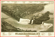 Niagara-Falls, N.Y. 1882. H. Wellge del. Beck & Pauli Lith. . Wellge, H. (Henry)
CREATED/PUBLISHED Madison, Wis., J. J. Stoner [1882] c1881. NOTES Perspective
map not drawn to scale. Bird's-eye view. Indexed for points of interest. Niagara-Falls, N.Y. 1882. H. Wellge del. Beck & Pauli Lith. . Wellge, H. (Henry)
CREATED/PUBLISHED Madison, Wis., J. J. Stoner [1882] c1881. NOTES Perspective
map not drawn to scale. Bird's-eye view. Indexed for points of interest.
|
1882
|
Niagara Falls, N.Y.
|
|
89
|
 Williams' commercial map of the
United States and Canada with railroads, routes, and distances, by W.
Williams. .
Williams, W. (Wellington) CREATED/PUBLISHED Philadelphia, 1855. NOTES Scale
ca. 1:4,400,000. Includes list of distances between major cities. Insets:
City & harbor of Havana.--Map of the Island of Cuba.--Map of the Niagara
River and Falls.--Map of California, Oregon, New Mexico, Utah &c. SUMMARY
Detailed general map of the eastern half of the United States framed in
decorative borders indicating drainage, cities and towns, canals, roads, the
railroad network, and indicating the proposed railroad routes to the Pacific
Ocean. Railroads in progress are indicated by dashed lines. Williams' commercial map of the
United States and Canada with railroads, routes, and distances, by W.
Williams. .
Williams, W. (Wellington) CREATED/PUBLISHED Philadelphia, 1855. NOTES Scale
ca. 1:4,400,000. Includes list of distances between major cities. Insets:
City & harbor of Havana.--Map of the Island of Cuba.--Map of the Niagara
River and Falls.--Map of California, Oregon, New Mexico, Utah &c. SUMMARY
Detailed general map of the eastern half of the United States framed in
decorative borders indicating drainage, cities and towns, canals, roads, the
railroad network, and indicating the proposed railroad routes to the Pacific
Ocean. Railroads in progress are indicated by dashed lines.
|
1855
|
North America
|